The auction will take place on Monday, June 26, 2023, at 19:00 (Israel time) with an announcement.
Dear customers, an interesting and important catalog containing many rare and important historical items in the many fields in which we deal, we are happy for any question, inquiry, and delivery of all the necessary information beyond what is written in the catalog.
|
ЛОТ 191:
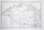
Atlas of the Five Maps - Plans to create a route from the Red Sea to the Mediterranean [Paris] 1802
далее...
|
|


|
Стартовая цена:
$
1 500
Комиссия аукционного дома: 23%
НДС: 18%
Только на комиссию
|
Atlas of the Five Maps - Plans to create a route from the Red Sea to the Mediterranean [Paris] 1802
Égypte. Atlas annexé au mémoire sur la communication de la Mer Rouge à la Méditerranée. - Egypt - an atlas attached to a report on communications from the Red Sea to the Mediterranean. Paris [l'Imprimerie Imperiale - Imperial Printing Office], 1802. The planning maps submitted to Napoleon to create a route from the Red Sea to the Mediterranean. Rare.
Large binder of maps and charts 53 cm. In the binder are 5 maps and folded plans - engravings. Original cover.
The "Five Plates" atlas, which was published as part of inspecting the possibility of building a modern canal from the Mediterranean to the Red Sea via the Suez Canal. The panels include a hydrographic map of Lower Egypt, a plan of the port of Suez, a plan and landscape of the "Fountain of Moses", a summary diagram of the various water levels, and a plan of the city and ports of Alexandria. The plan was submitted by Chief Engineer J.-M. Le Père to Napoleon in 1803. The table of contents (on the back of the title page) specifies that "these tables are part of the Great Atlas of the Work of the Commission of Egypt, Modern State" which was to be published in 1809.
During the 1798 Egyptian campaign, Napoleonic officers discovered the remains of the ancient "Canal of the Pharaohs", a west-east waterway built under the Persian Darius I, and connected the Nile to the Red Sea. Napoleon considered building a canal from north to south to connect the Mediterranean Sea with the Red Sea, and engineer Le Pré was commissioned to investigate the possibility of carving this canal. Although the plan was rejected because he mistakenly concluded that sea levels were different and that the waterway would require dams, the report actually formed the basis of Ferdinand de Leper's successful plans for the Suez Canal many decades later.
[7] Engraving plates - including three large folded maps. Two sized 93x58 cm, one 60x42 cm + [3] Maps and charts. Light moth marks on the upper part of some pages. Original red cover. Good Condition.


